GPR Service Division

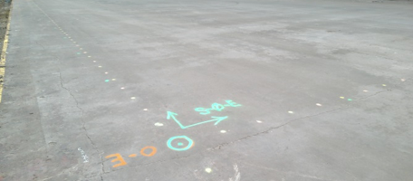
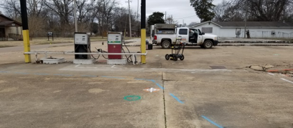
It’s your choice! From simple paint markings on the ground delineating boundaries and objects to totally georeferenced AutoCAD maps of subsurface targets with spatial and vertical relationships defined. This metadata from the survey can be imported as an “as built” of your site and imported into (BIM) building information modeling programs for the life of your project going forward. Simply update your AutoCAD file as structures are either added or deleted over the life of your site.

Having performed countless GPR investigations in the Southeastern US, we continue to exceed industry standards for accuracy, integrity and professionalism. We’ve applied our expertise in integrated geophysical surveying across a broad spectrum of industries, working on high-profile projects delivering detailed results on every project, large and small.

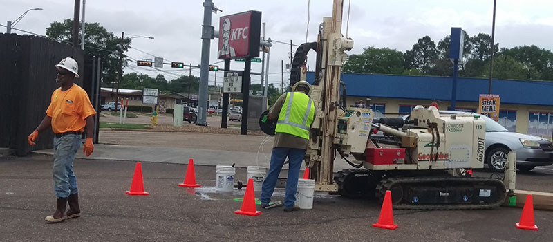
The value added realized by our Client is that the cost of the survey, geophysical data processing, and interpretation is negligible when compared to contracting invasive applications requiring property repair after investigations are complete. It is critical to know before you dig!

GPR is a remote sensing tool and as such does not work in all conditions, and can provide false readings especially in areas with high salt content in the soil, such as coastal areas, and tightly packed clay soils and rocks can prevent locating of structures with GPR.


Services Offered

Subsurface Utility Mapping (SUM)

Advances in digital data acquisition specifically related to remote sensing concepts, when combined with applications of integrated geophysical services, within the utility locating & mapping industry serves the needs of Facility Managers, Designers, and Excavators alike, while providing more value daily to Project Managers and Stakeholders. Ground penetrating radar (GPR) used in combination with other methods like electromagnetic detection (EM) and acoustic locating provides a much clearer ability to provide more accurate interpretations of subsurface data sets.

Soil Boring Clearings

Predominently serving the civil and geotechnical industries TeaCo will conduct utility clearing prior to the advancement of mechanical devices into the subsurface to provide a level of diligence to avoid strikes to add overall safety to projects. An integrated geophysical approach is taken to identify potential subsurface targets acitively or passively with the aid of electromagnetic (EM), acoustic, or ground penetrating radar (GPR) as required for any given site.

Concrete Structure Scanning

Situations occur where contractors and engineers are presented with a need to cut concrete for various reasons but are reluctant to do so knowing that engineered structures can be embedded within the concrete. Concrete structure scanning prior to saw cutting or concrete boring a designated location (floor, ceiling, wall) with a high resolution grid can be imaged in real time over the area of concern to effectively identify engineering concerns like spacing of rebar, location of post tension cables, power carrying conduits, voids and even fractures providing valuable information to the stakeholder. Our concrete imaging platform applies a 1000 mega-hertz GPR sensor that can collect data to concrete thicknesses up to 32 inches, emits no ionizing radiation and does not require work areas be evacuated during acquisition.

UST & Septic Tank Mapping

Locating and mapping of underground storage tanks (UST) is of critical concern to public welfare in that many historic filling stations never had records of where these tanks are buried on their properties and as time passes these begin to leak creating pollution sources into our groundwater systems. The need to accurately assess and identify the extent of burials and tank beds is paramount, and many State’s Departments of Environmental Quality provide oversight for remediation efforts. Often this need integrates proposed soil boring clearing while onsite as many Clients are required to safely advance monitor and observation well(s). Deliverable can be anything from paint marking upon the land surface, indicating “drill here”, to a fully scalable as built AutoCAD file created by a licensed professional land surveyor on staff in any specified coordinate system to accommodate your needs.

Cemetery Mapping

As our population ages many cemeteries are approaching the point where they are simply running out of space where a loved one can be properly interned. Cemetery mapping services is an arduous task that fully involves both parties to reconcile site specific issues. A GPR survey generally within the 250-500 mega-hertz range is appropriate to identify historic burials and differentiate them from areas that are available for sale. Naturally as one migrates back in time burial techniques become less modern. Detection can be difficult and as these cemeteries become more historic, one needs to recognize that burial methods have changed quite a bit over the last 200 years, making older burials harder to detect. Common applications for cemetery mapping can be from single GPR cross sections over a single grave, up to a fully georeferenced as built AutoCAD file of detected graves that can later be compared to historic records of past burials by facility management.